


Wifi Collector

คำอธิบายของWifi Collector
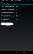
app นี้จะเก็บรวบรวมข้อมูลเกี่ยวกับเครือข่ายไร้สายและที่ตั้งของพวกเขาในขณะที่คุณกำลังเดินอยู่บนถนนหรือขับรถของคุณ
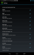
สำหรับเครือข่ายไร้สายทุกข้อมูลต่อไปนี้จะมีการเก็บ: ชื่อเครือข่าย (SSID) ที่อยู่ MAC ของจุดเข้าใช้งานของ บริษัท ที่ผลิตจุดเข้าถึงระดับสัญญาณความถี่ช่องจำนวนช่องทาง, การรักษาความปลอดภัย (WEP/WPA/WPA2) WPS ฝ่ายสนับสนุน (Yes / No), วันที่ / เวลาที่เครือข่ายได้รับการตรวจพบและที่ตั้งของเครือข่ายไร้สาย (ลองจิจูดและละติจูด) นำมาจากจีพีเอส
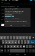
หลังจากรวบรวมข้อมูลเครือข่ายไร้สายคุณสามารถส่งออกเป็นไฟล์ CSV ไฟล์คั่นด้วยแท็บ, ไฟล์ HTML หรือ. ไฟล์ KML ของ Google Earth ที่ช่วยให้การดูสถานที่ตั้งของเครือข่ายการเก็บรวบรวมทั้งหมดที่อยู่ในแผนที่ของกูเกิล
การตรวจสอบนี้ต้องใช้อุปกรณ์ที่มีทั้งสององค์ประกอบ Wifi และจีพีเอส
คำเตือน!
การใช้งานของทั้งสององค์ประกอบ GPS และ wifi ได้โดย app นี้เป็นหนักมากดังนั้นในขณะที่ใช้ app นี้แบตเตอรี่ของคุณจะได้รับการระบายน้ำได้เร็วกว่าปกติ อย่าลืมที่จะคลิกปุ่ม Stop เมื่อคุณต้องการที่จะเสร็จสิ้นการเก็บรวบรวมข้อมูลไร้สาย
Wifi Collector--เวอร์ชั่น1.03
(13-04-2019)
Wifi Collector - ข้อมูล APK
เวอร์ชั่น APK: 1.03แพ็คเกจ: net.nirsoft.wificollectorเวอร์ชั่นล่าสุดของWifi Collector
เวอร์ชั่นอื่น


แอปในประเภทเดียวกัน

คุณอาจจะชอบ...


